In the comments on an earlier post, Alexwarrior mentioned that I should check out the revised bike routes at the south end of the Burrard St. bridge. I also wanted to see the relatively new bike route along Comox St. as well, which provides a connector between the Hornby bike lanes and Stanley Park.
This section of the Vancouver bike map shows a whole maze of routes at the south end of the Burrard St. bridge. It was time to hop on the bike to see them for myself.

Approaching the bridge from Kits along Cornwall, I see that there are new protected bike lanes just past the Cypress St. bike route.
This is the north side of the same intersection, showing how bikes that are westbound can turn south on Cypress.

Continuing east to the bridge, I see new green markings on Burrard St. Note also the bicycle green light.
Standing just on the other side of Burrard, but looking north, you can see how bike traffic headed across the bridge merges with the green bike crossing in the previous picture.

Headed north across the bridge, nothing much has changed from past years.

This bike rental place at Hornby and Pacific is new. In the lower right hand corner of the image, you can see that the green bike markings are a little the worse for wear in spots.

Not even one block north from the corner is another bike rental place, this one affliated with another bike shop that I had visited in the past.
Could this clustering of bike related business have anything to do with the improved bicycle infrastructure???
This signage along Hornby is new. I seriously doubt that I can walk 1/3 as fast as I can bike.

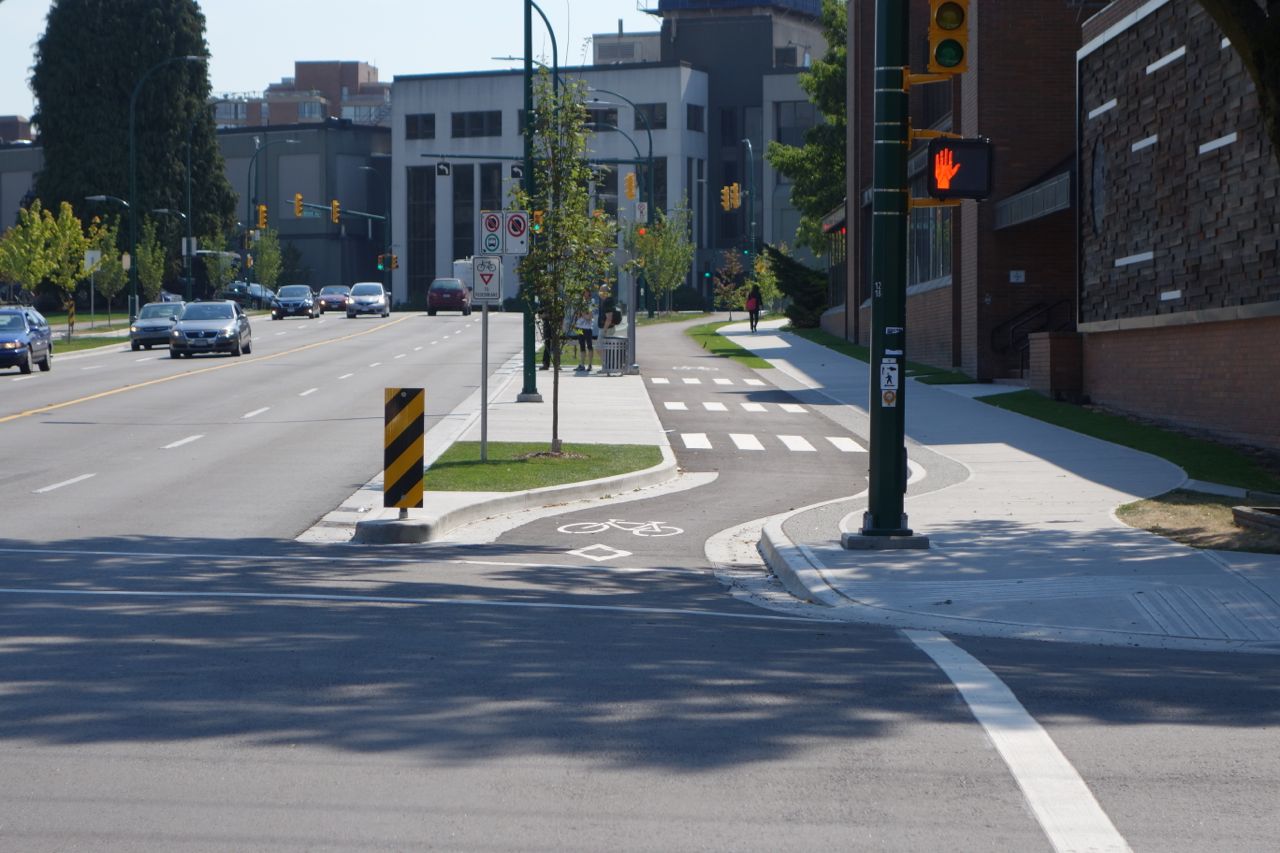
Here’s the intersection with the new bike along Comox. Note the attempt to mark a resting area for bikes from both directions on Hornby that want to turn west on Comox.

There is a short bit of bidirectional bike lane that turns right at Burrard.

This bit of the bike map shows the connection between these two bike routes, with the short segment shown in the previous photo, that jogs north before turning west.

Here is where the bike lane turns left (west) across Burrard onto Comox.

This I’ve never seen before: a wide bidirectional bike lane headed diagonally across a major intersection.

After crossing Burrard, the bike lane continues west. This first section is a separated bidirectional lane.
Here is a transition to a contraflow lane on a one way segment of the roadway.

This narrower section just has sharrows, with car traffic in both directions.

Crossing Denman, which is another busy street, there is another diagonal crossing.

From this point further west, the bike lane is a quite street that connects to Stanley Park. This signage on Denman indicates the “Greenway”.

Headed back towards downtown on Comox, here is another contraflow lane. Notice that the road markings include a buffer zone, unlike the ones in Toronto.

At the end of this same block, bikes are separated from cars making a right turn onto a one way street by transitioning to a bidirectional lane.

Looking back from roughly the same point, you can see sharrows that direct bikes to the bidirectional lane.

Now I’m headed south on Burrard towards the bridge. The painted bike lane is between a bus lane and the car traffic (as indicated by the signage).

Mixing it up with traffic, watching for merging buses: this is just like Toronto!

A couple of blocks before the bridge, we have a short segment of protected bike lane.

An attempt to separate pedestrians from bikes since the sidewalk here as been removed because of construction.

Now approaching the bridge. Bright green outlines the bike lane across major driveways.

Much better road markings at the intersection with Pacific.

Compare it to this picture taken a couple of years ago.

Crossing a right turn lane before the bridge.

Southbound at the south end of the bridge, bikes are now physically separated from two lanes of car traffic turning right.

Now you have the option of turning right into Kits, or continuing straight along Burrard.

This signs show that this routing is relatively recent?

If you turn right towards Kits, you get a short section of bidirectional that will connect to both the Cypress and the Seaside bikeways.
 Note that this means this section of roadway has a bidirectional bike lane in addition to the separated bike lane on the other side, shown in the second photo of this post.
If you continue south on Burrard, the crossing is clearly marked in green, with separate phasing for the bike traffic light.

After half a block, you can continue a short distance further south, or turn to the right towards the York bikeway.

Going south, the bike lane ends at 1st St.

If you turn right, here is another bidirectional bike lane.
It connects with Cypress here, and continues further to the west as well.

All in all, the city has done an amazing job with the south end of the Burrard St. bridge, giving cyclists numerous options to access the bridge within three of four small blocks. I cannot help comparing this to Toronto, where Sherbourne is offered up as an alternative to Jarvis, when these two parallel streets are about 300m apart.
Riding around Vancouver: always inspiring and a little depressing at the same time for this Toronto resident.

Make sure to visit again when the other phase of the Comox/Helmcken greenway is finished. We don’t know yet when that will be but probably next year. There’s also some stuff going on at the very south end of Cambie to connect up via separated bike lanes the Marine Drive canada line skytrain station area with the separated bik/walk deck on the North Arm bridge. Let’s see, what else… new wider walk/bike replacement sidewalks coming to the Second Narrows bridge, and some kind of improved separation on the Stanley Park Causeway leading to the Lions’ Gate bridge
You are so lucky in Vancouver. The highlights of what we can point to at this point in Toronto are the Sherbourne Bike Lanes (mixed reviews), various pilots on downtown streets being rolled out this summer, and in a few years, the Queen’s Quay and the Railpath extension. Also, there have been several off road trails like the Finch Hydro corridor that have been built in the suburbs, but these don’t service commuters so much.
Luck had little to do with it. It took a grass roots movement of all sorts of people organizing and working towards it. Also it took decades to get it to trickle up into politics where something like this was able to happen.
The Point Grey part of it had little to do with cycling as it was a neighbourhood desire for traffic calming along with a city wide desire to fill in a gap in the Seawall.
Hopefully this is only the start. Other parts of town are now eyeing this project and are pondering similar things for their neighbourhoods.
I agree that it takes years of advocacy to bring things like this about, but you do have some advantages in Vancouver such as an engaged region wide transit authority with funding (Translink) and a much more rational city planning process. We have Metrolink, which is relatively new and has no real money of its own, as well as the OMB.
Yes, it could not have happened this way without the social and political environment that exists on the coast. People are relatively active here and it’s important to them. (The people on the coast who are considered sedentary would be referred to as fairly active in other parts of the continent.) That’s one of the criticisms of Vancouver is there is not as much “city culture” as is found in other cities and the explanation for that is that it’s so easy for people to get out to nature and go hiking or paddle boarding instead of starting a festival or something.
There’s the now legendary anti-freeway movement in the 1970s that steered Vancouver in the direction that other cities are now going. Add to that traffic calming in some neighbourhoods back in the ’80s.
There’s a new phenomenon though, in areas such as the West End and Strathcona, which were traffic calmed decades ago, people who have benefitted from restriction to motor traffic and have had a beautiful walkable community for a long time, forget what created that and are griping about how hard it is to drive and are against any further improvements. Odd but I guess that’s going to happen.
I’m just glad that the suburbs don’t get to vote for Vancouver’s mayor.
as we head into another election with Ford running even with the other two candidates, I’m sure you feel my pain.
Got this response from the city on June.16th, so 6 weeks later i would think they would have had enough time to do the signage and painting needed and completed them 100%.
Here is a good project for you and your helmet cam to check these out and record their current status. 😉
The Port Mann bridge and it’s two way separated bike lane should be completed very soon as well i believe.
The 2nd narrows bridge bike lane expansion should be done in March, 2015 according to the city.
1) North end of Cambie Bridge Work is final stages. Last remaining paint should be in place by the end of the summer.
2) Richards Street bike lane from Richards/Robson to Richards /Drake Complete.
3) Adanac bikeway on Union Street/Gore till it runs into Carrall and turning off Union Project is substantially complete. There are minor sign and paint details to be finished.
4) Canada Line Bridge Pedestrian and Cyclist Connections Project Largely complete, and the paint & remaining signage work on it and Cambie should be done by the end of summer.